
GIS Support in DRL
Liz Hill
The University of Western Ontario has purchased a site license for ArcGIS 9.1 by ESRI (Environmental Systems Research Institute), a Geographic Information Systems (GIS) software product. This software and other GIS products are used extensively within the Department of Geography, and ArcGIS is now used by many departments across campus in order to perform GIS functions.
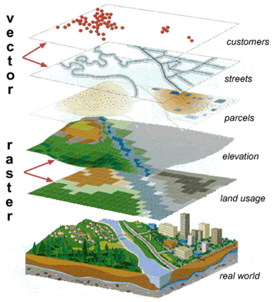
One definition for a geographic information system is that it is known for creating and managing spatial data and associated attributes. This system is capable of integrating, storing, editing, analyzing, and displaying geographically-referenced information. In a more generic sense, GIS is a "smart map" tool that allows users to create interactive queries (user created searches), analyze the spatial information, and edit data. For those who might be unfamiliar with GIS, the following graphic demonstrates how different elements within a GIS can be separated or ‘layered’ in order to combine features, and enable analysis of data.
Uses for GIS within our academic setting include the creation of new maps, spatial representation of census data, presentation of data such as incidences of disease within a particular geographic area as well as institutional planning.
Within Social Science Network and Data Services reference support for using ArcGIS software is available. ArcGIS is installable from the network to your desktop via Add/Remove Programs. It is also available for remote access via the sscnet2 server: connect to sscnet.uwo.ca and select sscnet2.uwo.ca from the server drop-down box. Data Resources Library (DRL) staff is able to provide introductory reference and support for ArcGIS desktop products.
Within the Faculty of Social Science, DRL is a logical placement for this software support resource because the digital map files are housed within the Library’s data delivery system, called IDLS (idls.ssc.uwo.ca). Support has been provided from DRL for the use of data sets and maps representing census geographic divisions in order to spatially represent data sets. DRL staff will be working closely with newly-hired Geography Department staff to provide easier access to geospatial data.
A dedicated workstation with dual monitors has been set up within DRL specifically for the provision of GIS reference support. A collection of software manuals and other printed reference materials have been added to DRL holdings, and they can be accessed within DRL and in some cases can be borrowed from the library. The ESRI site license also entitles members of the Western community to enroll in online training courses. For information on any of the levels of GIS services mentioned, please visit DRL in Room 1004 or contact Liz Hill (ethill@uwo.ca) or Vince Gray (vince@uwo.ca).
Also from this web page:
Managing Editor
- .:Mary Van de Ven